Sunday, February 26, 2012

Assignment, Week 4

  1. How is your city depicted on the web? Provide the U.R.L.’s of five sites that offer different views of your city’s popular life.
  2. Discuss one building of popular or political importance in your city. Describe its setting. Provide a photograph of this building (with label).
  3. Create a polygon and point to identify the site of this structure and the area in which it is located. Provide a screenshot indicating the location of your building in Google Earth.

See, this is where making a blog about Bangui gets (more) difficult. The problem with describing how Bangui is depicted on the Internet is that, by and large, it isn’t. The Central African Republic’s 123,800 Internet users make up only about 2.5% of the country’s population (Internet World Stats). Thus, it should come as no surprise that to find websites related to popular life in Bangui is exceedingly frustrating. Here’s what I found:

  • Journal de Bangui: A Central African newspaper, Le Journal de Bangui has something resembling the “standard” array of sections expected in a periodical—Société, Musique, Arts, etc.—as well as news. The society- and culture-related sections are useful for getting a peak into popular life: articles about the National Central African Theater Troupe and a book about urban development by a Central African expatriate remind the reader that such things exist even in a city as decrepit and poor as Bangui, though they also make one wonder how accessible they are to the general public.
  • “La Lettre de C.B.M.”: “La Lettre de C.B.M.” provides political and social commentary about happenings in Bangui and the Central African Republic. It is not a newspaper, and so has no obligation to be unbiased; the result is that the perspective is often quite jaded, ending posts with phrases like, « Oh Centrafrique, jusqu’à quand ? » (“Oh, Central Africa, how long?”)
  • “Letters to Bangui”: A Swedish doctoral student spent nine weeks in the Central African Republic researching security sector reform, and maintained a blog about her experiences. They give some insight into the positive and negative aspects of life in Bangui.
  • “Bangui, Capital of Misery”: Disregard this journal’s affiliation with an anarchist group, and it provides a telling, almost comical, account of poverty and bureaucratic corruption in the C.A.R., as experienced by a group of Irish tourists.
  • Le Confidant: I didn’t want to use another newspaper, but you underestimate the utter lack of online material about Bangui. This site, notable for its wretched design, also has several sections about popular life that appear to be updated about once a week. What is interesting to note is that there appears to be little overlap between the coverage of Le Confidant and Le Journal de Bangui.

Sô Zowa Laâ and BanguiWeb are good aggregations of links, images and information. The former is made for the Central African diaspora, and the latter is something like a travel guide, on the off-chance that someone wants to go on a relaxing vacation to Bangui (not recommended, by the way).

In the architecture of Bangui’s Palais d’Assemblée Nationale, one can see the grandeur envisioned by its French architects; in the overgrown lawn, the collapse of public services in the city is also readily apparent. Image: http://img4.hostingpics.net

There are several interesting buildings in Bangui—though, admittedly, fewer than in a lot of other cities. Here, let’s talk about the National Assembly building. Built between 1953 and 1960 by French architects Cazaban, Legrand, Janin and Sarkovitch, it was completed just in time for independence to house the 140 deputies of the Central African Republic’s unicameral legislature. It was designed in angular, modernist style with efficient ventilation in mind, and the architects deliberately used a variety of local materials in its construction (Christin and Filliat 268).

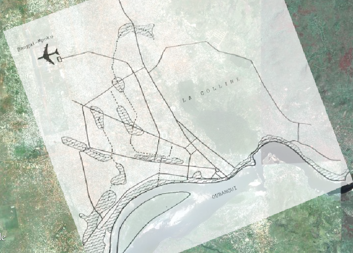
The Palais d’Assemblée Nationale is not in the city center; this area was filled to capacity by the French long before they even considered giving Ubangi-Shari any measure of self-governance. It is on the outskirts of what was the “European city” of the colonial era, on a thin strip of planned city north of the central roundabout between the densely packed ethnic quarters of Mandaba, Fou, Outala, Banga and Miskine (Villien 54).

The National Assembly building’s location in Bangui, with the surrounding neighborhoods labeled.

References

“Africa Internet Facebook Usage and Population Statistics.” Internet World Stats. 10 Feb 2012. Web. 26 Feb 2012 <http://www.internetworldstats.com/africa.htm#cf>.

Christin, Olivier, and Armelle Filliat. “Destin Des Villes De Pouvoir.” Architectures Françaises Outre-Mer. Ed. Pierre Mardaga. Liège: Institut Français d’Architecture, 1992. 259–271. Print.

Villien, François, et al. Bangui, Capitale d’un Pays Enclavé d'Afrique Centrale : Étude Historique Et Géographique. 4 Vol. Talence: Centre de Recherches sur les Espaces Tropicaux, Institut de Géographie, Université de Bordeaux III, 1990. Print. Pays Enclavés.

Sunday, February 12, 2012

Assignment, Week 3 (Part II)

Provide a short bibliography (minimum ten entries) of key academic or primary sources on your city.

I forgot to post this before—sorry! Anyway, here it is.

Amaye, Maurice. L’Identité des Populations Précoloniales de Bangui : Mythes et Réalités : Précisions Nouvelles d’Après les Sources Missionnaires. Bangui: 1991. Print.

Boulvert, Yves. Bangui, 1889–1989 : Points De Vue Et Témoignages. Paris: Ministère de la coopération et du développement, 1993. Print.

Bruel, Georges. L’Afrique Équatoriale Française : Le Pays — Les Habitants — La Colonisation — Les Pouvoirs Publics. Paris: É. Larose, 1918. Print.

Fedangaï, Jean. “Origines Diplomatiques et Politiques de la Création de Bangui.” WaMbesso 1.1 (1989): 6–28. Print.

Kalck, Pierre. Historical Dictionary of the Central African Republic. Lanham: Scarecrow Press, 2005. Print.

Pounouwaka, Martin. Les Explorateurs en Oubangui-Chari, 1884–1914. Bangui: Sanza Edition, 1996. Print.

“Les Rapides Du Haut-Oubangui.” Bulletin Société Royale Belge du Geographie 18 (1894): 494–501. Print.

Villien, François, et al. Bangui, Capitale d’un Pays Enclavé d’Afrique Centrale : Étude Historique et Géographique. 4 Vol. Talence: Centre de Recherches sur les Espaces Tropicaux, Institut de Géographie, Université de Bordeaux III, 1990. Print.

Woodfork, Jacqueline. Culture and Customs of the Central African Republic. Westport: Greenwood Press, 2006. Print.

Zarhy, M. Les Centres Urbains et Régionaux de la République Centrafricaine. Jerusalem: Institut de Planification et de Développement S.A., 1963. Print.

Assignment, Week 3

Write a short history of your city. Include screenshots of your main points highlighted with polygons, points, and lines. When was it founded, by whom, and under what circumstances? What does the name of your city mean? What is the broader significance of this history and name? What questions does this name raise? What if any earlier names were there?

The area around Bangui was historically inhabited by the Bobangi, a merchant people who lived along the Ubangi River. They participated, if indirectly, in the Atlantic trade, which brought them European products in exchange for commodities like ebony, ivory and slaves (Amaye 4).

Europeans, meanwhile, were just beginning to explore Central Africa. France and Belgium’s King Léopold II both had colonial ambitions in the Congo, and a rivalry arose around the competing expeditions of the French Pierre Sauvorgnan de Brazza and the Belgian-funded Henry Morton Stanley in the 1870s.¹ The Congress of Berlin made the Congo River the official border between the French Congo and Léopold’s Congo Free State in 1885, and a contemporaneous Franco-Belgian treaty made the Ubangi River (as yet largely unexplored) the northern boundary (Pounouwaka 2–3).

In the following years, a succession of expeditions explored and charted the Ubangi River. A Belgian post was founded at Zongo in 1885 on the east bank near the rapids of modern Bangui (Pounouwaka 9). To make up for lost time,² in July 1889, a French post was built at the rapids and christened Bangui, from the French interpretation of the local word for “rapids” (Fedangaï 13).³ It had rough beginnings due to local hostility, flooding, and shortages of personnel and medicine. In four years, the command of the post changed hands nine times and the installation itself had to be moved twice (Villien et al. 22).⁴

Sites of the three successive posts set up by the French. The settlement across the river is Zongo.

In 1903, when Bangui was made the capital of the newly formed colony of Ubangi-Shari, it began to expand into a city, instead of two conjoined clearings in the forest (Villien et al. 26). By 1912, it had administrative buildings, a hospital and a hotel, and over 1,000 residents. The European population of Bangui grew steadily, quadrupling between 1911 and 1934; the African population, however, grew from 2,000 to 20,000 in the same period (Fedangaï 26). As the European city expanded, African towns sprouted on its periphery (Villien et al. 40). In the 1920s, roads were built and automobiles introduced, easing communications with the interior (Fedangaï 27).

Bangui, as it existed in 1930; as the city expanded, indigenous villages sprang up on its outskirts, all of which were later engulfed by urban sprawl. (Villien, et al. 40, overlaid onto Google satellite imagery)

After World War II,⁵ all travel restrictions were lifted, prompting a huge influx of Africans to Bangui; by 1956, the city had a population of 72,000, of whom only about 1,000 were European. This “rural exodus” slowed by the late 1950s, as the region’s unpredictable political climate discouraged investment (Villien et al. 43–44).

It was around this time that thoughts of independence first became prominent. France gave citizenship to residents of its colonies, and allowed for representatives from the colonies to sit in the National Assembly. The first of these, Barthélemy Boganda, charismatically called for full independence with “voluntary interdependence.” In 1958, Ubangi-Shari gained autonomy with Boganda as its executive (Villien et al. 44–45). The next year, however, on the eve of full independence, he died in a plane crash.⁶ David Dacko succeeded him as the first president of the independent Central African Republic. Dacko’s authoritarian rule ended in 1965 with a coup by Jean-Bédél Bokassa. Bokassa brutally ruled for 14 years, at one point crowning himself emperor of the new “Central African Empire” before being ousted in 1979.⁷ Dacko was reinstated, then promptly ousted by André Kolingba. An election in 1993 brought Ange-Felix Patassé to power, for the longest period of civilian rule in the C.A.R.’s history before he, too, was ousted in 2003 by the current president, François Bozizé (Woodfork 15–17).

This instability, unsurprisingly, has led to an exceedingly poor investment climate, difficulty governing and inability to provide basic services. The population of Bangui has ballooned to over 600,000, in part because it is the only part of the country which the government can reliably control (Brinkhoff). Public services have collapsed, buildings and roads are maintained little if at all, and there are continual strikes and riots over lack of pay by civil servants. In addition, flooding in 2005 left 20,000 people homeless and outbreaks of cholera and yellow fever have claimed many lives in recent years (Woodfork xxi). Bangui, at the moment, is calm, but remains constantly on the edge.

Areas of Bangui that are prone to flooding (Villien, et al. 61, overlaid onto Google satellite imagery)

Footnotes


¹ At around this time, campaigns by the Bobangui threatened to displace the Bateke, their neighbors to the south. Makoko, the king of the Bateke, was concerned enough that when de Brazza wandered in and offered to make the kingdom a French protectorate in 1880, he eagerly accepted (Amaye 4). A French outpost was established on the west bank of the Congo River which would become Brazzaville; a Belgian city, Léopoldville (now Kinshasa), was promptly built directly across the river. Thus, the French gradually dominated the land west of the River, and Belgians the east.
² The first French mission to be sent up the Ubangi was led by Albert Dolisie in 1887. At Mossaka, a major Bobangui city in modern Congo-Brazzaville, the fleet was routed and forced to retreat. Shortly after, a military expedition was sent to burn Mossaka and install a French garrison there. Through all this, despite their willingness to trade, the Bobangui were determined not to be displaced by Europeans, and mission after mission was met with hostility (Amaye 5).
³ There were two existing towns in the area of the rapids called “Bangui,” now distinguished as “Bangui I” and “Bangui II” (Amaye 4).
In one of the more dramatic incidents, post overseer M. Maurice Musy was ambushed, killed and eaten while trying to intervene in a local conflict (Amaye 6). Conditions were so poor that the authorities in Brazzaville considered abandoning Bangui entirely, though in the end its strategic position was deemed valuable enough to be maintained (Fedangaï 17–18).
Ubangi-Shari sided with the Free French during the war, thereby separating itself completely from France and forcing it to become self-sufficient—which, to the chagrin of those involved, meant the institution of mandatory collection of rubber and cotton so infamously destructive in the Congo Free State (Villien et al. 42).
Boganda was a larger-than-life figure to the citizens of Ubangi-Shari, to the point that he was nearly deified. On the day of his death, crowds gathered at the shores of the Ubangi River waiting to see him walk on water (Le Vine 238).
The French government supported Bokassa in coming to power, and continued to support his regime; this included paying for most of his coronation ceremony, whose total cost of $20 million was equivalent to the country’s entire annual G.D.P. It took a massacre of dozens of schoolchildren in which Bokassa personally took part before France withdrew its support, eventually sending troops to help with his ouster (Woodfork 15–16).

References

Amaye, Maurice. L’Identité des Populations Précoloniales de Bangui : Mythes et Réalités : Précisions Nouvelles d’Après les Sources Missionnaires. Bangui: 1991. Print.

Brinkhoff, Thomas. “Central African Republic: Prefectures and Cities.” CityPopulation. 15 May 2009. Web. <http://www.citypopulation.de/Centralafrica.html>.

Fedangaï, Jean. “Origines Diplomatiques et Politiques de la Création de Bangui.” WaMbesso 1.1 (1989): 6–28. Print.

Le Vine, Victor T. ”Experiments in Power, 1958–2003.“ Politics in Francophone Africa. Boulder: Lynne Rienner Publishers, 2004. 201-240. Print.

Pounouwaka, Martin. Les Explorateurs en Oubangui-Chari, 1884–1914. Bangui: Sanza Edition, 1996. Print.

Villien, François, et al. Bangui, Capitale d’un Pays Enclavé d’Afrique Centrale : Étude Historique et Géographique. 4 Vol. Talence: Centre de Recherches sur les Espaces Tropicaux, Institut de Géographie, Université de Bordeaux III, 1990. Print.

Woodfork, Jacqueline. Culture and Customs of the Central African Republic. Westport: Greenwood Press, 2006. Print.

Sunday, February 5, 2012

Assignment, Week 2

  1. Briefly describe your city’s setting (environment) and its most notable features.
  2. Compare the different Google Earth "views" of your city (satellite, hybrid, roadmap, terrain, physical, street map). Compare two different neighborhoods using Google Earth satellite. How does your city appear in 1675 and 1770 maps (AfricaMap). Where does your city lie in malaria distribution?
  3. Locate and mark (using Google Earth) the main city center and avenues/streets coming into it. Include screen shots of your results.
  4. Discuss your city using five different layers of AfricaMap. Provide screen shots in your overview.

Bangui is situated in central Africa on the Ubangi River, at a point where the river pivots and begins flowing south instead of west from its source in the eastern Congo. The distinguishing feature of this segment of the Ubangi is a series of treacherous rapids which make it very difficult to navigate (“Les Rapides du Haut-Oubangui”). Inland to the north is sporadically forested savannah (Blier). Bangui is approximately 400 m above sea-level, with a forested hill approaching 600 m just north of the city center (Google Maps).

A simple Google roadmap of Bangui shows a neatly gridded, logically spaced district in the southeast corner of the city, close to the river; moving inland, there are at least a dozen vaguely rectangular, irrational clusters of streets that look more like tangram solutions than planned neighborhoods. Switching to satellite view reveals the reason: the city begins to disintegrate within 2 km of the city center. Planned neighborhoods give way to informal assemblages of small, white roofs which have roads in the most unusual arrangement—or none at all.¹ From a high enough elevation, these houses look very much like grains off salt shaken onto an uneven surface.

The nicely organized city center (bottom right) quickly gives way to a disorganized hodgepodge of ethnic slums.

The other features that jump out of the satellite image are the colors of Bangui. Two predominate (besides the white of the roofs): a dark green and a light reddish-brown. Green is the backdrop for every manmade feature in the city, from the spacious planned areas by the center to the cramped inland slums.² Reddish-brown is the color of dry, equatorial dirt, and is therefore also of most of Bangui’s roads.³ Only a few of the major thoroughfares are paved; the rest are simply worn down. In case there was any doubt, the Central African Republic is one of the world’s least-developed countries, and looking at a satellite picture of Bangui reinforces the impression that its capital is really not far removed from nature; unlike other cities, Bangui’s residents appear to coexist with their environment, rather than mastering it.

Admittedly, it has not had much time; the city is only about 125 years old (though some would point out that many newer cities have come out looking a lot better). Indeed, before the 1880s, no Europeans had ever navigated the Ubangi River—or even known it existed (“Les Rapides”).⁴ To early modern European cartographers, the entire interior of Africa was unknown and therefore to be filled with anecdotes and fantasy. Early maps tended to include the current location of Bangui at the eastern edge of the imaginary Kingdom of Biafar, just west of the make-believe Lake Niger and near the invented town of Guidan.⁵

The Gbaya, Ngbaka and Banda (left to right, respectively) converge on Bangui (outlined in red).

Though each is different, most ethnographic maps convey that Bangui is located approximately at the intersection of three ethnic groups: the Banda, the Gbaya and the Ngbaka-Ma’bo (Blier), which are linguistically similar but culturally distinct (Villien et al. 12–13). Partially because this, Bangui’s outskirts now comprise many semi-enclosed ethnic quarters (Adrien-Rongier).⁶

If one is interested in avoiding tropical diseases, one should stay away from Bangui. At just 4.36º N, it enjoys year-round malaria, and the adjacent prefecture of Ombella-M’poko reported a yellow fever outbreak in 2009 that required over 300,000 emergency immunizations (Blier; “Yellow Fever in the Central African Republic”).

Other layers of AfricaMap show that the C.A.R. has had a somewhat unusual history for an African country. To start, unlike other areas, its growth was not stunted by the slave trade because it is so far inland (Blier). On a different note, the Armed Conflict Location and Events Dataset lists numerous events in Bangui, enough to rival Freetown or Mogadishu but of a different nature: in other failed states, violence in the capital often means a rebel group overrunning the government. In the C.A.R., this has never happened; here, most conflicts have involved mutinous government troops or rioting civilians, all usually discontented due to poor governance and inadequate pay (Blier).⁷

Bangui’s City Center, With Main Roads Marked

The city center is at the bottom right, and the Ubangi River runs horizontally just off the map to the south.

Footnotes


¹ The hybrid view shows that, in some cases, Google’s map-tracers simply gave up and left some of the smaller roads off of their street-map.
² In the planned central district, it is likely that the colonists made a conscious choice to include abundant vegetation, but everywhere else the implication seems to be that the trees were simply never cleared.
³ Astute readers might remember from the first post that most of the Central African Republic consists of ferralsols, soils which are distinctive for their mineral deficiency and high iron content, from which comes their reddish color (“Ferralsols”).
The first European to navigate the Ubangi was the English pastor George Grenfell; he reached the area of what would become Bangui on 13 October 1884 (Pounouwaka 9).
The name “Biafra,” as in the secessionist Igbo region of Nigeria, is etymologically derived to this “Biafar,” but most of the locations so named on old maps have no resemblance to what would later be known as Biafra.
This agrees with what Europeans found when they arrived and founded the city, and even after the founding of the colonial city there were several African towns of various ethnicities on its outskirts (Villien et al. 40).
To be sure, the Central African Republic has had its fair share of revolts (some ongoing), but these have mostly been concentrated in the north and have been associated with spillover violence from Chad, Darfur and Southern Sudan (Polgreen). The unusual location of the capital in the southwestern corner of the country may have inadvertently made it easier to defend from said rebels.

References

Adrien-Rongier, Marie-France. “Les Kodro de Bangui : Un Espace Urbain « Oublié ».” Cahiers d’Études Africains 21.81/83 (1981): 93–110. Print.

Blier, Suzanne. ”AfricaMap.” WorldMap. 29 Jan 2012. Web. 29 Jan 2012 <http://worldmap.harvard.edu/africamap/>.

“Ferralsol.” Encyclopædia Britannica. Encyclopædia Britannica Online Academic Edition. Encyclopædia Britannica Inc., 2012. Web. 29 Jan. 2012. <http://www.britannica.com/EBchecked/topic/707602/Ferralsol>.

“Google Maps.” 5 Feb 2012. Web. <maps.google.com>.

“Les Rapides Du Haut-Oubangui.” Bulletin Société Royale Belge du Geographie 18 (1894): 494–501. Print.

Polgreen, Lydia. “Central Africa Guard Unit is Implicated in Atrocities” The New York Times, New York ed., sec. World: A12. Web. 16 Sep 2007.

Pounouwaka, Martin. Les Explorateurs en Oubangui-Chari, 1884–1914. 2 ed. Bangui, 1996. Print.

“Yellow Fever in the Central African Republic.” 5 Feb 2012. Web. <http://www.who.int/csr/don/2009_12_01/en/index.html>.

Friday, February 3, 2012

If I Didn’t Know Better…

…I would say there wasn’t much interest in the history of the Central African Republic around here. No one seems to know that Bangui even exists, and of the eleven relevant books I got from the library earlier today, only two of them had ever been checked out.

These are the books, in case anyone else thinks they’re as cool as I do:

  • Amaye, Maurice. L’Identité des Populations Précoloniales de Bangui : Mythes et Réalités : Précisions Nouvelles d’Après les Sources Missionnaires. Bangui, 1991. Print.
  • Boulvert, Yves. Bangui, 1889–1989 : Points de Vue et Témoignages. Paris: Ministère de la Coopération et du Développement, 1993. Print.
  • Bruel, Georges. L’Afrique Équatoriale Française : Le Pays — Les Habitants — La Colonisation — Les Pouvoirs Publics. Paris: É. Larose, 1918. Print. *Previously checked out in 1922, 1924, 1925, 1927, 1929, 1936, 1941, 1959 and 2003.
  • Godart, Louis, and Cyprien Zoubé. Nos Pères Dans la Foi : Les Anciens de la Mission Saint Paul. Bangui: Foyer de Charité de Bangui, 1986. Print.
  • Houlet, Gilbert. Afrique Centrale : Les Républiques d’Expression Française. Paris: Hachette, 1962. Print. *Previously checked out in 1963 and 1965.
  • Pounouwaka, Martin. Les Explorateurs en Oubangui-Chari, 1884–1914. 2 ed. Vol 1. Bangui, 1996. Print.
  • Remy, Jules. Voyage Preparatoire à la Fondation de la Mission Saint-Paul des Rapides : Bangui 9–17 Fevrier 1893. Bangui: Publications du Centenaire de l'Église Catholique en Centrafrique, 1994. Print.
  • Saulnier, Pierre. Bangui Raconte : Contes de Centrafrique. Paris: L’Harmattan, 2000. Print.
  • Tinturier, Dominque. Crise Économique et Développement Urbain à Bangui : Le Cas de l’Activité Productivité des Femmes. [Bangui]: s.n, 198[?]. Print.
  • Université de Provence Institut d'Histoire. Recherches Centrafricaines : Problèmes et Perspectives de la Recherche Historique : Sénanque, 24–25 Septembre 1981. Vol 16. Aix-en-Provence: Institut d’Histoire des Pays d’Outre-Mer, Université de Provence, 1982. Print.
  • Villien, François. Bangui, Capitale d’un Pays Enclavé d’Afrique Centrale : Étude Historique et Géographique. Vol 4. Talence: Centre de Recherches sur les Espaces Tropicaux, Institut de Géographie, Université de Bordeaux III, 1990. Print.

It’s an odd mix of neatly printed colonial-era books with abundant illustrations and beautiful fold-out maps, and crudely typewritten theses published by people affiliated with the University of Bangui. The one uniting characteristic is that they are in French—a language which I can sort of read, and which I plan to get much better at reading in the near future.

All upcoming posts on this blog will deal directly with Bangui. The first assignment was a sort of warm-up. There will be assigned posts due on Sundays; other posts, like this one, are there just because I felt like posting something.